Mapping and Responding to Coastal Inundation
Introduction
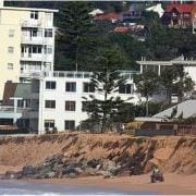 Given that it is impossible to stop climate change impacts and resultant sea level increases and more intense significant storm events, Local, State and Federal authorities are faced with the need to consider key areas at immediate to medium threat. This information needs to then be applied to planning mechanisms and management strategies to cope with future impacts of increased coastal inundation and erosion directly impacting existing, redeveloped and new development within their coastal landscape areas.
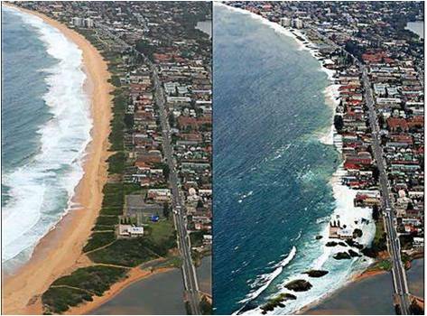 This project maps areas of risk, utilising sophisticated modeling together with Councils own information sources Inundation(eg LiDAR technology) to determine risk and develop consistent model planning and management responses in consultation with relevant state government agencies and the broader community.
In 2009 the SCCG secured grant funding under NDMP to undertake the project with the CSIRO entitled Mapping and Responding to Coastal Inundation
Aims and Objectives
- Enhance the capacity and knowledge of local governments and other decision makers in the region to prepare for and adapt to climate change (specifically focusing on sea level rise and extreme water levels, eg storm surges),
- Develop an approach to climate change assessment and adaptation with a particular focus on relevant planning provisions in identified immediate and future coastal inundation (flood) zones and potential beach erosion escarpments,
- Develop and distribute associated community risk disclosure information and corresponding community and stakeholder education programs to better inform communities of the degree of risk(s).
Project Outputs
The SCCG engaged the Environmental Defender’s Office NSW (EDO) to conduct a comparative assessment of:
- Australian State and Territory planning and coastal legislation and policies that address sea level rise, coastal erosion, coastal inundation and storm surge; and
- regional and international jurisdictions.
The results of this analysis are presented in the report prepared by the EDO, a copy of which can be downloaded by clicking on the following link:
Audit of Sea Level Rise, Coastal Erosion and Inundation Legislation and Policy
For the Stage Outcome Reports, please click on the report titles below.
Stage 1: Effect of Climate Change on Sea level Rise and Extreme Sea Levels:
A set of high resolution hydrodynamic model simulations were produced in order to obtain current climate, as well as storm tide return level estimates and sea level rise considerations.
- Assess existing planning strategies (Australia and Internationally)
- Identify gaps in information, knowledge, capacity or external barriers
- Develop model provisions, actions and implementation strategies
Assess existing education strategies within Australia and Internationally for addressing and communicating sea level rise and flooding impacts.
- Consultation with member councils and targeted community groups and individuals to identify gaps in information, knowledge and capacity as well as internal and external barriers for message transfers.
- Utilising outcomes of stage 1 and 2 and incorporating the above to develop and deliver freely available educational tools that build the understanding and capacity of relevant stakeholders.
PROJECT LAUNCH
Southern Function Room, Town Hall House, 4 October 2012.
This project was launched to assisted attendees to understand project outcomes and outputs to take back to their own organisations for use.
There was a Panel Discussion with the key speakers of the day. This allowed attendees to ask questions about the project outputs and the NSW 2012 Stage One Coastal Reforms.
The launch also involved the establishment of a secure and temporary FTP server to provide Member Council access to the project outputs including all mapping information, stage outcome reports and associated meta date information.
Click here for the Project Launch Report.
Click here for the NCCARF Climate Change Adaptation Good Practice Case Study of the SCCG Mapping and Responding to Coastal Inundation project.